At the end of 2021, we are taking a moment to look back at a year’s worth of impactful AWC GIS Consortium projects. We’ve selected five to highlight for you. These projects helped streamline catch basin data, highlighted where traffic collisions
occur, enabled residents to search cemetery plots, highlighted local transportation efforts, and planned for a smooth permitting system transition.
Are you interested in learning more about the program and how to become a member? Visit here for more information.
Catch basin inspection application, City of Lake Forest Park
The City of Lake Forest Park used its AWC GIS Consortium service hours to implement electronic field forms to make catch basin inspections more efficient. Before implementing the field form, City of Lake Forest Park needed to clean up its current catch
basin data. AWC GIS Consortium services provider FLO Analytics developed a new data schema that streamlined merging datasets and filled in missing data. After streamlining, FLO built an electronic form that allows people working in the field to add
new information collected to a main catch basin database.
Now, the City of Lake Forest Park public works inspectors complete two simplified tasks when they are documenting information in the field: they perform an inspection using an electronic form, and with the new data scheme, they continue the data cleaning
process. An inspector can use a custom ArcGIS Online application to select a catch basin, fill in any attribute information, and then click a link to a form where they can perform an inspection using a form created from Survey123.
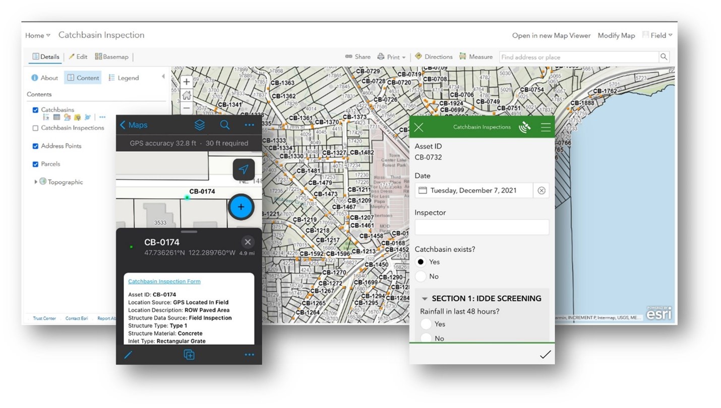
Using the catch basin inspection map on the left, inspectors can view and edit catch basin attributes. Using the link at the top of the attribute table they can go directly to the inspection form on the right. Data is updated live so people working in the office can immediately see the inspection results.
Washington State police data processing, City of Arlington
The City of Arlington used its AWC GIS Consortium service hours to automate data processing tasks related to traffic collision data the City of Arlington receives from the local police department and the Washington State Patrol. Once handed the data,
FLO standardized and then geocoded these data so that decisionmakers can see the locations of traffic collisions on a map. FLO also built two tools to help with this process. The first takes local police department data, standardizes data values,
and prepares it for geocoding. The second does the same for State Patrol data from its website. The City of Arlington can now use these tools to quickly get the data ready for the next step and onto the map.
Cemetery application, City of Leavenworth
The City of Leavenworth used its AWC GIS Consortium membership to create a cemetery application that makes it easy for anyone to search for a deceased person by name, birth date, or death date. Accessible through any web browser, the application allows
the user to quickly see a filtered list of plots that meet their search criteria, along with each plot’s geographic location in the cemetery. An additional search tool allows one to search for all plots available for purchase and highlights
available plots on a map of the cemetery. This application is a significant improvement over City of Leavenworth’s previous cemetery application, which did not include these sophisticated search tools.
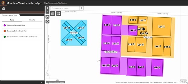
The cemetery application makes it easy for non-GIS users to find plot locations.
Development activity map updates, City of Sammamish
City of Sammamish has been a GIS Consortium member for many years now and has previously used the program to build a development activity application that displays permitted development activity on an easy-to-use map for the public to view. With a planned
upgrade of their Community Development permitting system (formerly TRAKiT) looming, the City of Sammamish worked with FLO to smooth the transition, ensuring that the development activity map was up and running with the new system as quickly as possible.
FLO worked closely with the city and the vendor to test the new system and implement the changes needed to support the switch from a mapping perspective.
This project also tested GIS data loading, made changes to the configuration for the city’s special cases, and provided troubleshooting assistance with the various integrations involved in the system. To ensure maximum sustainability, City of Sammamish
staff will receive training the new procedures as the migration is completed.
Local transportation funding options for Washington cities storymap
To encourage the Washington State Legislature to adopt a new transportation revenue package that emphasizes increased local transportation resources, AWC worked with FLO to create a storymap highlighting the unique challenges and approaches Washington cities (including two AWC GIS Consortium members) are taking to address transportation funding.