The Columbia River begins its 1,200-mile journey at Columbia Lake, a glacial pool nearly 3,000 feet above sea level in British Columbia. From there, it cuts northward through the Canadian Rockies before descending into Washington, where it winds swoopily southward before turning west to form most of the state’s southern border with Oregon and emptying into the Pacific Ocean.
Lining the river’s middle stretch in eastern Washington, the cities and towns that grew up along the Columbia heavily depended on its flow as a source of water for irrigating dryland wheat crops or as a maritime superhighway for barges and freighters hauling that bounty to distant markets. And thanks to hydroelectric dams that tamed rapids to make the river accessible for shipping and harnessed electricity in the process, the Columbia has served as a never-ending generator powering economic growth.
Near where the river takes its final westward tack some 300 miles from the Pacific, the City of Kennewick, incorporated in 1904, owed much of its early prosperity to its proximity to the Columbia. Its namesake Port of Kennewick was founded in 1915 as a riverside terminal for steamboats that began ferrying passengers and freight to and from Portland and Astoria, Oregon, aided by the opening of a navigational canal that shunted maritime traffic around Celilo Falls, about halfway to the ocean. After a flood in 1926 destroyed the docks and other infrastructure, shipping activity subsided until the 1940s, when the Port of Kennewick purchased Clover Island and leased it to Columbia Marine Shipyards, which built tugboats and barges for the war effort. But Clover Island’s success was short-lived: when another flood in 1948 inundated the shipyard, it ended the port’s involvement in dock and barge loading facilities.
In recent decades, Kennewick is booming again. Its population has doubled since 1990, from just over 40,000 to nearly 83,000 in 2018; together with neighboring Richland and Pasco, it forms a Tri-Cities metropolitan area whose total population now exceeds 300,000. The mainstays of the Tri-Cities economy include research & development (such as at Battelle’s Pacific Northwest National Laboratory in Richland, which employs 4,365) and food processing (combined, Con Agra and Tyson Foods employ just over 4,000). More recently, the abundance of cheap hydropower generated by the upstream Grand Coulee Dam has lured a digital-age farming industry: server farms, that is (a.k.a. data centers), including one operated by Amazon.
Adjusting to the times, during the past decade Kennewick’s port and city have reevaluated their relationship with the river, targeting crumbling industrial infrastructure along the waterfront as ripe for redevelopment, but of a different sort.
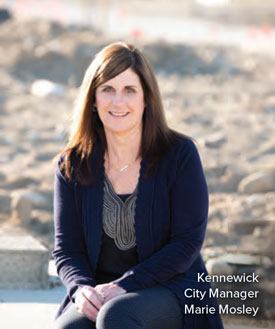
“Over many years, when Kennewick first became a city, we turned our backs on the beautiful Columbia River that we have,” says Kennewick City Manager Marie Mosley. “And the shoreline in Kennewick was used for industrial purposes rather than for enjoying the shoreline and the recreational opportunities that it provides.”
No place was riper for redevelopment than Clover Island and the Columbia Drive area adjacent to Duffy’s Pond. The pond, a retention basin embraced by acres of tired industrial buildings, storage lots, pawn shops, and auto-body shops, lies just inland from the island, sandwiched between a levee and East Columbia Drive, a busy thoroughfare that parallels the river.
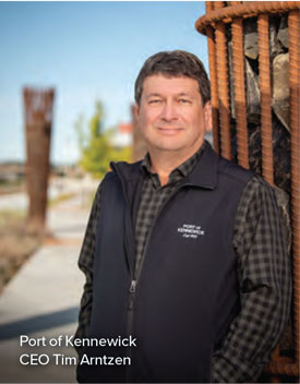
“It’s the eastern part of the community and the older part of town, and those early floods and resulting river levee kind of sucked the lifeblood out of our downtown,” says Port of Kennewick CEO Tim Arntzen. “For a number of years, the port and the city were trying to do something to revitalize the area we call the downtown core—the waterfront—but I’m not sure how effective each party was.”
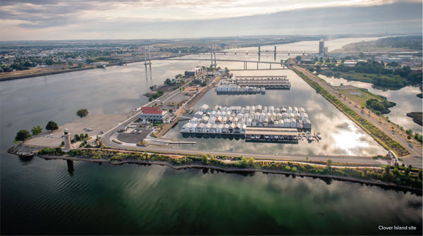
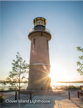
Hence the current excitement over the frenzy of construction on Clover Island, and on Columbia Drive around Duffy’s Pond, that started a decade ago. Partnering with the Confederated Tribes of the Umatilla Indian Reservation, the port built a 62-foot navigational lighthouse on the island (completed in 2010) with a 15,000-square-foot plaza for special events and weddings that’s become a favorite place for residents to gather and watch sunsets. They also rebuilt a private marina into a 150-slip public facility, added a restroom and nine public artworks, and created a pedestrian promenade (dubbed the Clover Island Riverwalk) connecting the island to the Sacagawea Heritage Trail (a 23-mile paved recreation path atop the levee system) and to Duffy’s Pond and Kennewick’s historic downtown.
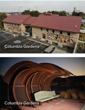
Back ashore, the strip of tired industrial buildings between Columbia Drive and the pond was cleared to make way for the Columbia Gardens Wine & Artisanal Village, a complex of wineries and tasting rooms that opened in 2018. Anchored initially by Bartholomew Winery and Monarcha/Palencia Wine Company, it expanded in late March to include Cave B Estate and Gordon Estate wineries, plus a food truck plaza for six vendors connected to city utilities. The port spearheaded the development (which received a 2017 Smart Communities Planning Award), while the city anted in a winery wastewater pre-treatment facility that it will continue to own and manage.
That’s just the beginning of the buzz in Kennewick. Having honed their ability to work together along the waterfront, the city and the port are now taking their collaboration inland to Vista Field: a 103-acre decommissioned general aviation airfield, also owned by the port, that abuts Kennewick’s entertainment and shopping district six miles west of Clover Island.
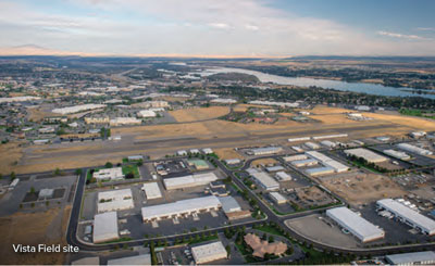
After a four-year community visioning process, anchored by a citizen task force that convened a series of public meetings and surveys, the project will be guided by the principles of “new urbanism”: 1,000 residential units that include a mix of housing for all ages and incomes, pedestrian-friendly infrastructure like 10-foot-wide sidewalks and small-scale multiuse streets, parks and other open public spaces, and 740,000 square feet of retail and office space (some in repurposed airport hangars). Upon completion, Vista Field will become a residential and commercial and cultural hub of the whole Tri-Cities area.
With support from the City of Kennewick and Benton County, the Port of Kennewick broke ground on Vista Field in April 2019, priming the old airport for development: installing underground infrastructure, streets, sidewalks, a linear park, water features, landscaping, and a plaza. Once Phase One (of an envisioned eight) is completed this year, the port will finalize plotting parcels, create a property owners association, set pricing, and begin marketing available lots in Vista Field’s central 20 acres for commercial, retail, and residential development. Real estate transactions will fund ensuing phases of construction until buildout is complete.
“It’s not really our downtown area, but it’s the center of the Tri-Cities area,” says Mosley. “And it was very close to our major retail hub in the city of Kennewick, so you can just imagine what an airport’s restrictions on building in the middle of the retail hub does to development.”
All that should change once the airport has been replaced by a regional town center that’s expected to generate $460 million in private-sector investment, $408 million in new (taxable) real estate, and $51 million in new infrastructure—and create 3,380 new jobs. That’s economic activity the city couldn’t generate alone.
“The City of Kennewick recognized, and the port as they approached us, that these are important projects,” says Mosley. “Individually, it’s very difficult to get projects like this moving forward, but together, along with leveraging grant dollars and other partnership opportunities, we can make these things happen. Even though they’re very big projects, we felt like we could work together, and the timing was right to move them forward.”
Part of that leverage included tapping the Rural County Capital Fund, which supports new capital infrastructure projects that contribute to job growth and economic diversity in Benton County by utilizing a state sales tax rebate to help spur investment. Partnerships with county and tribal stakeholders helped move the project along.
But it was the cooperation between the city and the port that really turned both underused properties, at Vista Field and Clover Island/Duffy’s Pond, into assets for a growing community. The port took a leading role in developing the master plan for the projects, which included organizing the public engagement sessions for the Vista Field project and working in conjunction with developers. But Arntzen says what really helped move both projects forward was the willingness of city officials to adapt zoning and building codes and provide public utilities like the wastewater treatment facility at Columbia Gardens.
“We have 76 port districts in the state, and we have a bunch of cities, and not very many port districts work very well with their city partners—and that’s kind of where we were,” says Arntzen. “The thing that I’m most proud of is that we now have a great working relationship with the City of Kennewick. . . . I don’t care how many great projects you have, if you don’t have a trusting relationship, I know for a fact there’s not much you can do that will be meaningful.”
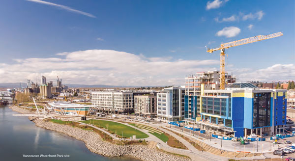
More than 200 miles downriver, Vancouver is also in the midst of construction on its own renewal project—redeveloping 32 acres along to the Columbia River in a project that, as in Kennewick, is reconnecting its waterfront to the city’s downtown core. Historically, Vancouver’s waterfront had been dominated by a sulfur-belching paper mill, empty warehouses, and an old railroad berm running along the riverbank that separated the Columbia from the rest of town. When the mill shuttered in 2006, Vancouver’s waterfront devolved into a hollowed-out no-man’s land, with only one road in or out.
“It was heavy industrial, and it hadn’t been super active for many years. . . . The public couldn’t get down there; it was all fenced off,” says Chad Eiken, Vancouver’s director of community and economic development. “The city wondered what would happen if that [industry] went away, and what it would take to make that part of downtown, so that had been talked about for almost 20 years.”

In 2008, a group of investors, Columbia Waterfront LLC, purchased the property with ambitious plans for a mixed-use development. Then the recession hit, and plans stalled. Meanwhile, the city struck up an alliance with the new property owners in an effort to find common ground for the vision.
“We didn’t own any of the property there, so we had very little control over how the property would develop other than through our regulations, but we also recognized that financial participation by the city would be needed,” says Eiken. “A lot has changed since the first development agreement, but we still have the same developers and same investors. . . . What’s been helpful is that the local investors didn’t get skittish even during the recession. They put a lot of money into buying the property, and they were patient.”
What’s been helpful is that the local investors didn’t get skittish even during the recession. They put a lot of money into buying the property, and they were patient.”
Chad Eiken, Vancouver’s Director of Community and Economic Development
In addition to rezoning the parcel for mixed commercial and residential development, the city anted in $40 million (with funding from the US Department of Housing and Urban Development’s Community Development Block Grant program and capital grants from the state Legislature and the governor’s office) to create two new street connections through the old railroad berm that isolated downtown from the river and expand access to the waterfront. Then the developers, after soliciting community input, created a master plan to guide the process, which was reviewed and approved by the Vancouver City Council.
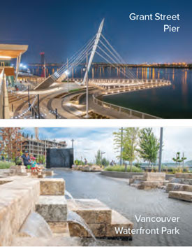
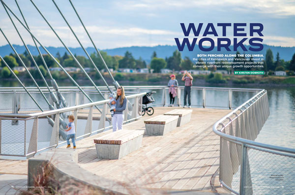
In total, Vancouver’s Waterfront Development Project will add 20 new blocks to the cityscape, creating 3,300 residential units, over a million square feet of office space, 250,000 square feet of retail space for new restaurants and shops, a network of recreation paths for cyclists and pedestrians, and public green spaces, plazas, and water features. The project’s signature 7.3-acre Waterfront Park (a half-mile-long linear park connecting the development with a five-mile-long waterfront recreation path, the Columbia River Renaissance Trail) was completed in 2018, along with Grant Street Pier—a cable-stayed boardwalk that cantilevers 90 feet out over the Columbia River and offers a dramatic and iconic backdrop for the first wave of new upscale restaurants, bistros, wineries, tasting rooms, and taprooms that opened that year and in 2019.
Once completed, the $1.5 billion development promises to create 10,000 new jobs and contribute over $385 million in tax revenue to the local economy over 30 years. It also promises to make Vancouver, often overshadowed by its neighbor on the south bank of the Columbia, a regional destination, with newly accessible waterfront leisure options just blocks from an equally bustling downtown of new galleries and internationally tinged restaurants extending out beyond beloved Esther Short Park.
“We’re used to being compared sort of unfavorably against Portland,” says Eiken. “So it has resulted in a sense of pride over what Vancouver did and that we can do big things. . . . We still hear comments from people that they can’t believe that it’s Vancouver.”
At press time, amid the uncertainty of the Covid-19 pandemic, developers were still optimistically forging ahead with Phase I of the project, which, along with Waterfront Park and the Grant Street Pier dining and entertainment establishments, includes 45,000 square feet of ground-floor retail, a 138-room boutique hotel, 270 apartment units, and a fountain dubbed Headwaters Wall. Once normalcy returns, the hope is that crowds will be eager to explore and embrace the city’s ever-evolving riverfront refuge, as they did when the city cut the ribbon on Waterfront Park in September 2018 and 30,000 Vancouverites showed up, including dignitaries like US Senator Maria Cantwell.
“I don’t know if people realize how important rivers are to us culturally,” Cantwell remarked at the ceremony. “When you think about it, they’re a metaphor for life. And here we have a river that goes from the headwaters of Canada all the way to the Pacific, and now we get to enjoy a little path of it as it flows through the city of Vancouver.”
As do the citizens of Kennewick. Leaders from Vancouver’s upriver cousin echo a similar optimistic outlook about reinvesting in their local stretch of waterfront real estate. At press time in late March, as Cave B Estate and Gordon Estate wineries opened their tasting rooms in a new building that in February was added to the Columbia Gardens Wine & Artisanal Village, Pasco’s Columbia Basin College was planning to add a $13 million culinary school to the development on Duffy’s Pond. Meanwhile, with Vista Field still years away from completion, the city has been encouraged by the public’s enthusiastic embrace of the city’s long-neglected properties.
“We were a little bit worried with the wine village location: there weren’t a lot of things that brought you there, and it was a blighted area, so people stayed away,” says Mosley. “But there’s a lot of excitement. Throughout the spring, summer, and fall, there are lots of little events—the wineries might bring in a band or something that attracts visitors—and the community has come out and supported it. And Vista Field is exciting just because it’s so different, providing a tremendous opportunity.”
And amid uncertain times, it’s an investment in the future: a bet that the best is yet to come.